
Padangbai
Padangbai | |
|---|---|
 Padangbai Location in Bali | |
| Coordinates: 8°31′S 115°30′E / 8.517°S 115.500°E | |
| Country | Indonesia |
| Province | Bali |
| Time zone | UTC+8 (Central Indonesia Time) |
| 80871 | 80871 |
Padangbai is a small coastal town in the Karangasem Regency, in south-eastern Bali, Indonesia. It serves as a ferry port for travel to Lembar on Lombok, The Gilis and other Lesser Sunda Islands.
.jpg)
Location[edit]
Padang Bai is off the road that follows the south-east coast of Bali.[1] It sits 35 miles (56 km) north-east of Denpasar Airport (1 hour 19 minutes drive in fluid traffic), 27 miles (43 km) north-east of Sanur Beach (1 hour fluid drive), 23 miles (37 km) east of Ubud (some 62 minutes fluid drive), 8 miles (13 km) west of Candidasa,[2] and 11 miles (18 km) east of Semarapura.[1]
Notable places[edit]
Beaches and diving[edit]
Padangbai includes four beaches and several diving spots of international reknown.
- Main Beach
Immediately East of the port, this long narrow beach is bordered by the main street, Jl. Silayukti.[1]
Diving: the Ferry Channel site is near the green beacon that marks the starboard side of the narrow channel used by the ferries for Lombok. It features several horizontal steps, with some overhangs that create shallow crevices of various heights and good hideout places for a diverse fauna. This site goes down 30 metres and more.[3]
- Blue Lagoon Beach
Also known as Padang Kurungan[citation needed] or Padang Bai Beach.[1]
Diving: there are 6 different sites, suitable from beginners (mild to moderate currents) to professional divers, very diverse. The shallow coastal reef has a maximum depth of 25 metres with a slope and a short wall. The visibility is around 25 metres or more.[3] Here are some of the sites:
The Temple site is a shallow (5 to 9 metres) in front of the small temple built into the lava cliffs. It is rather well protected from the currents. Beyond the sand, the reef edge follows along the sandy slope to a depth of 24 metres.[3]
The Tanjung Sari dive site is at the southern end of the Blue Lagoon, stretching along the cape that separates the Blue Lagoon from the Padang Bai harbour. It features a protruding reef top with volcanic rock formations, which slopes down to about 30 metres and ends in a sandy bottom.[3]
The Drop Off site is at the junction of the Blue Lagoon and the Amuk bay to the northeast. It is a rocky cape that continues under water as a vertical wall, down to a depth of 30 metres.[3]
The Jepun site is on the west coast of Amuk Bay, northeast of the Blue Lagoon. There is an artificial reef with a small shipwreck, sunk on purpose in 2008 at 18 meters depth, and some Buddha statues.[3][4]

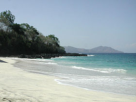
- Bias Tugal Beach
Also known as Pantai Kecil, Little Beach, Secret Beach or White Sand Beach, it is close to the market - but reaching it means a 1.4 km detour by road. It is about 130 m long.[1] The name means ‘Separated Sand’ (bias for 'sand', tugal for 'cut', 'separation'), because this is where the volcanic black sand beaches of the south-east coast gives room to pure white sand.[5]
Diving: The entire bay has a flat bottom (9 metres) covered with soft coral and several boulders bearing hard coral. At about 50 metres from the beach, the seafloor makes a 45 degree angle sloping down, with a horizontal ledge at 20 metres.[3]
- Black Sand Beach
Also known as Mimba Beach, Black Pearl Sand Beach[citation needed] or Kusamba Beach. Salt mining operation.[6]
Temples[edit]

The following temples are located at Padangbai:
- Pura Silayukti sits on the small peninsula east of town.[1] The most important historical site in Padang Bai, dating from the 11th century.[6] Empu Kuturan, who introduced the caste system to Bali in the 11th century, is said to have lived there.[7]
- Pura Telaga Mas, immediately north of Silayukti temple.[8]
- Pura Tanjung Sari, immediately south of Silayukti temple.[1]
- Pura Tirta Segara Muncar, at the end of the peninsula where Silayukti temple sits.[1] Tirta indicates a water temple.
- Pura Dalem, in town, north of the harbour[9]
- Pura Pesamuhan, west end of Jl Silayukti.[10]
- Pura Penataran Agung, west of the harbour[11]
- Pura Mumbul, south of the harbour[1]
- Pura Puseh, north-west of town[12]
Salt mining[edit]
Kusamba, a village by the stretch of black sand south-west of Padangbai, traditionally harvests salt right on the beach near the Goa Lawah temple. Seawater is collected in buckets and poured into a basin where the water evaporates in the sun over a course of a couple of days. The salt is then transferred to a filtering rake and the operation is repeated a few times. This arduous process gives a salt with a unique and distinct flavor which is slowly getting recognized as a typical Balinese product and more reknown around Bali. Well-established restaurants have started using it and it is sold in shops around Bali.[2] There is a natural salt market in Kusamba.[13]
Coral restoration[edit]
Livingseas, located east of Padang Bai just north of the Blue Lagoon Beach, aims at building a 5-hectare coral reef. Starting in 2019, they use hexagonal steel structures coated with resin and sand, anchored on the seabed close together to maximize coral density and fasten the colonization process. It takes about 2 years before the structures disappear unders the growing corals. They also train local youths and clean up the garbage they may encounter. As of 2024, 2,719 m² of seabed has thus been revitalized.[14]
Gallery[edit]
-
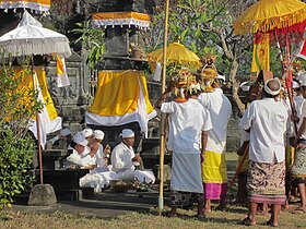 Ceremony at Silayukti temple
 -
 Pura Penataran Agung
 -
 Bias Tugal Beach
 -

-
![View east from the hill on the western side of the port: Candidasa over the wider bay, and the rock of Gili Bia[15] jutting out in the Lombok Strait](//upload.wikimedia.org/wikipedia/commons/thumb/1/13/Lombok_Strait_-_panoramio.jpg/315px-Lombok_Strait_-_panoramio.jpg)


![View east from the hill on the western side of the port: Candidasa over the wider bay, and the rock of Gili Bia[15] jutting out in the Lombok Strait](/wiki/File:Lombok_Strait_-_panoramio.jpg)
References[edit]
- ^ a b c d e f g h i "Padang Bai, map". google.com/maps.
- ^ a b "Padangbai, Where Travelers Go Beyond Bali". greenerbali.com. Retrieved 2024-05-15.
- ^ a b c d e f g "Bali Dive Sites - Worldclass Diving". waterworxbali.com. Retrieved 2024-05-16.
- ^ Verrips, Jojada (2015). "Religion under Water" (PDF). Etnofoor, The Sea. 27 (1): 75–88. Retrieved 2024-05-13. See p. 80.
- ^ "Bali Dive Sites - Worldclass Diving". waterworxbali.com. Retrieved 2024-05-15.
- ^ a b "Padang Bai". finnsbeachclub.com. Retrieved 2024-05-15.
- ^ "Pura Silayukti". lonelyplanet.com. Retrieved 2024-05-15.
- ^ "Pura Telaga Mas, map". google.com/maps.
- ^ "Pura Dalem". google.com/maps.
- ^ "Pura Pesamuhan Agung, street camera view". google.com/maps.
- ^ "Pura Penataran, Padang Bai, map". google.com/maps.
- ^ "Pura Puseh dan Bale Agung, 5 Angentelu - Padangbai, street camera view". google.com/maps.
- ^ "Kusamba Traditional Salt Mining, map". google.com/maps.
- ^ "Livingseas Coral Restoration". livingseasfoundation.org. Retrieved 2024-05-15. See also "Impact" tab.
- ^ "The rock of Gili Bia, map". openstreetmap.org.
External links[edit]
- "Padang Bai - The Best Place to Dive and Stay in Bali". gekodivebali.com. Retrieved 2024-05-13.